Alaska, Summer of 2000 Glenn ViceŠ2000
Click on the image to enlarge it, then click your "back" button to come back to this page.
Amazing land of
contrasts. Lush vegetation, backed by an
iceberg-filled lake, backed by snowcapped mountains.
Happy Campers at the Forest Service cabin at Harlequin Lake
Shhh!!! Scrabble "Championship of the World" game in progress.
Harlequin Lake Forest Service Cabin 40LT passes Mount Hood
It is difficult to
get a perspective from a photograph that doesn't include
recognizable objects like a person or a boat, but the pinnacle
in the third photo is 80 to 100 feet tall. The tallest bergs in
the
middle photo stand in excess of 75 feet above the water level.
Intrepid crew of the Minnow set to sea for a "three hour tour."
The
"large office building" sized iceberg in the center of the photo on
the right started
breaking up and rolling over as we cruised by within 100 yards in our 11'
Zodiac -- very exciting. Despite all of the noise and the 30-foot high
splashes as
cabin-sized pieces broke away, there was only a small wave generated. The
fact that there was only a small wave may be explained by the huge amount of
energy absorbing slush ice that filled the whole area within 75 yards of the
iceberg
during and after the breakup. The slush ice contained chunks ranging in
size from ice
cube size to VW bug size.
Playing tugboat, but the icebergs seem to be winning.
Exploring the
icebergs of Harlequin Lake. The field of bergs is
so thick and so many "passage ways" are blocked that we
actually used a GPS with a moving map to find our way
back through the iceberg field to the mouth of the
Dangerous River (actual name) where we had launched
the Zodiac.

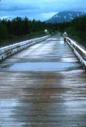
The bridge over the
Dangerous River is at the end of a 30-mile gravel
road from Yakutat. The road literally ends 30 yards beyond the bridge at
the trailhead
that goes 1/4 mile back to the Harlequin Lake Forest Service cabin and the
airstrip ( next photo).
The bridge is made of 1 1/2 inch-thick laminated planks.
The weather box
(below) shows the temperature at the airport, about
25 miles from
Harlequin Lake and about 35 miles from the Yakutat Glacier. It's colder on the
lake among the icebergs -- especially when the wind blows across the ice.
Because the lake sits up against the mountains, the area around the
lake tends to have more rain and adverse weather than 25 miles away
at the airport.

AlaskanWeather Cams
showing current conditions.
What appears to be
a "toy ship" in the photo is a beached logging ship that is
probably 300 feet long. The ship is on the beach a few miles east of Icy
Bay.
I don't know when it went aground, but it was there in 1994.
Two views of the
west end of the Martin River Glacier as we
flew by westbound at about 1000 feet agl and a few hundred feet
below the overcast. The glaciers are located a few miles east of the
Copper River Delta in Southeast Alaska and about 30 miles east of the
scenic town of Cordova (below).
The airport for
Cordova is located in the center of the picture.
If you look at the enlarged image you will see 8 or 10 airplanes
parked on the right side of the runway against the hill. A nice
marina is in the background. Our next trip will definitely
include a stop in Cordova to have a look around.
The very small town of Whittier has become the latest tourist mecca. Until recently it was only accessible by rail, air, and sea. A multi-million dollar construction project widened and paved the railway tunnel on the route from Anchorage. Traffic flows through the tunnel alternate between inbound and outbound -- 15 minutes of inbound traffic and then 15 minutes of outbound traffic, except when the train is running and then all of the cars wait.
It is difficult to
say exactly what the license-plate "body count" is, but don't
let anyone try to tell you that Alaska doesn't have mosquitoes. In fact,
we
were really lucky that the locals told us about these steel traps (shown
below with a ballpoint pen for comparison). Once we were in the tent for
the
night, we would set a dozen or so of these around the inside of the tent
(especially around our pillows) to catch the smaller mosquitoes that
had sneaked in when the zippered door was opened. The primary
drawback to this method is that we would be awakened when these
traps would clank shut and the mosquito would go into a frenzy
of buzzing. The only solution was to pull out the .22 rifle to
put the mosquito out of its agony and to stop that infernal buzzing.
These are just a
few of the photos from June, 2000.
For some interesting facts and fun reading try Alaskan Memories